While many assume that with time comes -often dramatic- change, research shows that one things often hasn’t: Where you find Indigenous peoples, you may find some of the largest areas of intact natural resources.
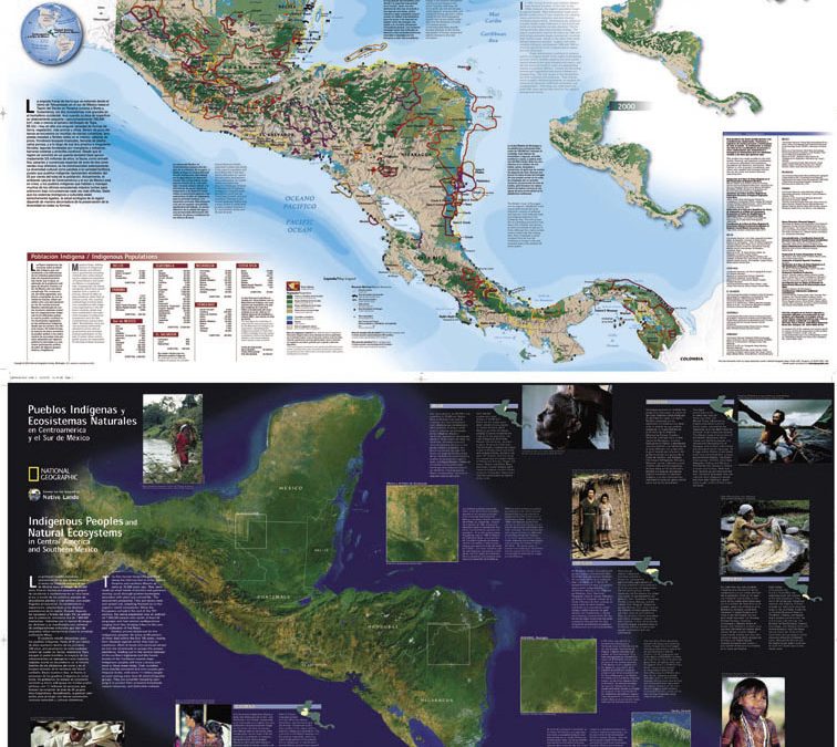
In 1992, the Center for the Support of Native Lands collaborated with National Geographic on a project mapping the existing Indigenous groups of Central America. The Center had worked for years with Central American indigenous people. Together with National Geographic, they created a bilingual Spanish-English map titled The Coexistence of Indigenous Peoples and the Natural Environment in Central America.
To create this map, they used Indigenous surveyors selected by local community leaders, trained them in creating hand-drawn maps by a skilled architect and cartographer, and sent them out with two questionnaires, one dealing with the use of natural resources and the other to ascertain the population of the region. Each surveyor covered several territories, collecting data and drawing maps. They collaborated with the villagers in each area, particularly village elders, to gather census data as well as meticulous drawings or river systems, hunting areas, locations for gathering medicines and fruit, as well as the areas from which locals gathered firewood and construction materials.
The initial goals of this project were essentially twofold: to use the resulting map of Central America as a tool in the fight to mark the land occupied by Indigenous peoples as inhabited, rather than empty, and to aid the securing of land rights for these villages. Several other beneficial outcomes were also derived from this process:
- Indigenous villages often were secluded, not just from the outside world but from each other. The inhabitants of these areas did not realize the extent to which areas were threatened, for they did not have a global vision of the encroaching threat to their natural resources. Before the project began, individual villagers had little sense of how loggers, cattle ranchers, and landless peasant farmers were affecting the resources within the region as a whole. This mapping process raised their awareness of the numerous threats and opened dialogue between these constituencies on developing a collective strategy to combat the threat.
- At the same time, conservationists were able to see that the relatively untouched land, full of natural resources and diverse ecosystems matched almost exactly the land inhabited by the Indigenous people. This led to the potential conclusion that the best way to preserve the resources we have left was to create or increase Indigenous control over the land.
The impact of the first map was powerful, and in 2001, the Center for the Support of Native Lands collaborated with National Geographic again to update the map, this time titled Indigenous Peoples and Natural Ecosystems in Central America and Southern Mexico. This map was also bilingual, and encompassed a larger area. It included marine ecosystems in addition to the terrestrial areas, and was much larger in scope in terms of expert involvement and community participation. In this map, technological advances in satellite imaging and digital data played a large part in relieving some of the burden of the previous project’s more laborious hand-drawn cartography. This new map again showed that forest and marine resources in Central America and southern Mexico, while broadly dwindling, were impacted for the better in areas inhabited by Indigenous peoples.
In early 2016, another map, “Indigenous Peoples, Protected Areas and Natural Ecosystems in Central America,” was financed by the Danish government, in conjunction with National Geographic, and produced by the International Union for Conservation of Nature (IUCN). While the 2001 map relied on satellite imagery that was unable to closely detail marine ecosystems or see beneath dense forest canopies, this survey included previously overlooked bodies of water and topographical elements. Mac Chapin, who was the leader and driving spirit behind the first two maps, was involved again as technical advisor to the newest team. “If we want to protect the world’s forests, we must safeguard the rights of the indigenous peoples and forest communities who have sustainably managed their forests for generations,” said Helen Clark, the administrator of the U.N. Development Program, at the recent New York signing of the Paris Agreement on climate change. “Clarifying local land rights and tenure security will be a crucial determinant of success for the new global frameworks on climate change and sustainable development.” This project was well characterized on the Humanosphere web site.
In current events, we see a different, more modern example of indigenous people and the protection of ecosystems around them. Although the Central American map project did not provoke major confrontations, similar indigenous issues exist in the U.S. At Standing Rock Indian Reservation, located in both North and South Dakota, the tribe filed suit against the Dakota Access Pipeline in the spring of 2016, alleging that the Army Corps “violated multiple federal statutes, including the Clean Water Act, National Historic Protection Act, and National Environmental Policy Act, when it issued the permits.” The plaintiffs claimed that “The Army Corps has failed to follow the law—both regarding the risk of oil spills and the protection of their sacred places.” In addition to the lawsuit, a protest began in the proposed path for construction of the pipeline, where a Standing Rock Sioux elder established a camp as a center for cultural preservation and spiritual resistance to the pipeline. Over the summer the camp grew to thousands of people, and while the pipeline remains controversial, and the protests were met by the use of attack dogs, pepper spray, and a mix of soldiers and police in riot gear to clear the encampment, the events surrounding the DAPl have been said to be “reshaping the national conversation for any environmental project that would cross the Native American land”.